ಚಿತ್ರ:India climatic disaster risk map en.svg
Jump to navigation
Jump to search

Size of this PNG preview of this SVG file: ೫೩೦ × ೫೯೯ ಪಿಕ್ಸೆಲ್ಗಳು. ಇತರೆresolutions: ೨೧೨ × ೨೪೦ ಪಿಕ್ಸೆಲ್ಗಳು | ೪೨೫ × ೪೮೦ ಪಿಕ್ಸೆಲ್ಗಳು | ೫೩೧ × ೬೦೦ ಪಿಕ್ಸೆಲ್ಗಳು | ೬೮೦ × ೭೬೮ ಪಿಕ್ಸೆಲ್ಗಳು | ೯೦೬ × ೧,೦೨೪ ಪಿಕ್ಸೆಲ್ಗಳು | ೧,೬೩೯ × ೧,೮೫೨ ಪಿಕ್ಸೆಲ್ಗಳು.
ಮೂಲ ಕಡತ (SVG ಫೈಲು, ಸುಮಾರಾಗಿ ೧,೬೩೯ × ೧,೮೫೨ ಚಿತ್ರಬಿಂದುಗಳು, ಫೈಲಿನ ಗಾತ್ರ: ೬೬೦ KB)
Summary
| Description |
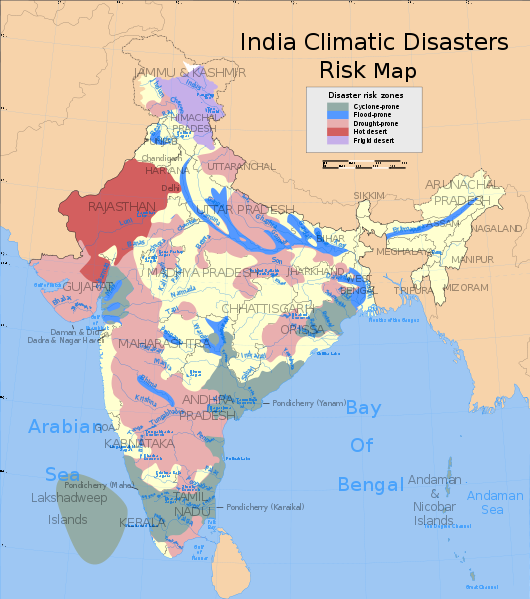
English: Map showing zones shaded by risk of climate-related natural disaster in India
|
| Date | |
| Source | https://commons.wikimedia.org/wiki/File:India_climatic_disaster_risk_map_en.svg |
| Author | Saravask, based on map work by Planemad and Nichalp |
Licensing

|
Permission is granted to copy, distribute and/or modify this document according to the terms in Creative Commons License, Attribution-ShareAlike 4.0. The full text of this license may be found here: CC by-sa 4.0 |
ಕಡತದ ಇತಿಹಾಸ
ದಿನ/ಕಾಲ ಒತ್ತಿದರೆ ಆ ಸಮಯದಲ್ಲಿ ಈ ಕಡತದ ವಸ್ತುಸ್ಥಿತಿ ತೋರುತ್ತದೆ.
| ದಿನ/ಕಾಲ | ಕಿರುನೋಟ | ಆಯಾಮಗಳು | ಸದಸ್ಯ | ಟಿಪ್ಪಣಿ | |
|---|---|---|---|---|---|
| ಪ್ರಸಕ್ತ | ೦೪:೪೧, ೨೪ ನವೆಂಬರ್ ೨೦೧೬ | | ೧,೬೩೯ × ೧,೮೫೨ (೬೬೦ KB) | Soumya | {{Information |Description ={{en|1=Map showing zones shaded by risk of climate-related natural disaster in India}} |Source =https://commons.wikimedia.org/wiki/File:India_climatic_disaster_risk_map_en.svg |Author =Saravask, based on m... |
ಕಡತ ಬಳಕೆ
ಈ ಕೆಳಗಿನ ಪುಟವು ಈ ಚಿತ್ರಕ್ಕೆ ಸಂಪರ್ಕ ಹೊಂದಿದೆ: